
Location on Maps
Most maps allow us to specify the location of points on the Earth's surface using a coordinate system. For a two-dimensional map, this coordinate system can use simple geometric relationships between the perpendicular axes on a grid system to define spatial location. Figure 1 illustrates how the location of a point can be defined on a coordinate system.
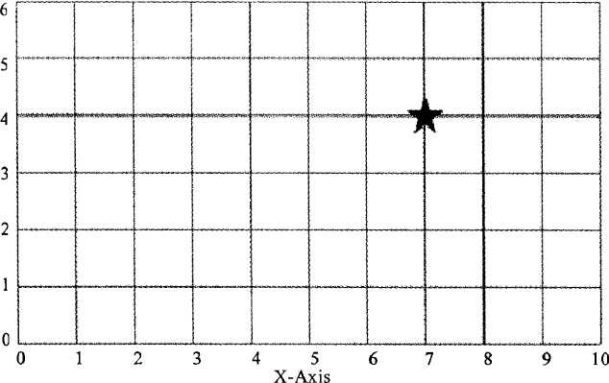
Figure l A grid coordinate system defines the location of points from the distance traveled along two perpendicular axes from some stated origin. In the example above, the two axes are labeled X and Y. The origin is located in the lower left hand corner. Unit distance traveled along each axis from the origin is shown. In this coordinate system, the value associated with the X-axis is given first, following by the value assigned from the Y-axis. The location represented by the star has the coordinates 7 (X-axis), 4 (Y-axis).
Two types of coordinate systems are currently in general use in geography: the geographical coordinate system and the rectangular (also called Cartesian) coordinate system.
Geographical Coordinate System
The geographical coordinate system measures location from only two values, despite the feet that the locations are described for a three-dimensional surface. The two values used to define location are both measured relative to the polar axis of the Earth. The two measures used in the geographic coordinate system are called latitude and longitude.
Latitude measures the north-south position of locations on the Earth's surface relative to a point found at the center of the Earth (Figure 2). This central point is also located on the Earth's rotational or polar axis. The equator is the starting point for the measurement of latitude. The equator has a value of zero degrees. A line of latitude or parallel of 30° North has an angle that is 30° north of the plane represented by the equator (Figure 3). The maximum value that latitude can attain is either 90° North or South. These lines of latitude run parallel to the rotational axis of the Earth.

Figure 2: Lines of latitude or parallels are drawn parallel to the equator as circles that span the Earth's surface. These parallels are measure in degrees (°). There are 90 angular degrees of latitude from the equator to each of the poles. The equator has an assigned value of 0°. Measurements of latitude are also defined as being either north or south of equator to distinguish the hemisphere of their location. Lines of longitude or meridians are circular arcs that meet at the poles. There are 180° of longitude either side of a starting meridian which is known the Prime Meridian. The Prime Meridian has a designated value of 0°. Measurements of longitude are also defined as being either west or east of the Prime Meridian.
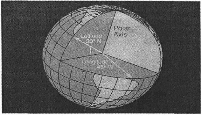
Figure 3 Measurement of latitude and longitude relative to the equatorand the Prime Meridian and the Earth's rotational or polar axis
Longitude measures the west-east position of locations on the Earth's surface relative to a circular arc called the Prime Meridian (Figure 2). The position of the Prime Meridian was determined by international agreement to be in-line with the location of the former astronomical observatory at Greenwich, England. Because the Earth's circumference is similar to circle, it was decided to measure longitude in degrees. The number of degrees found in a circle is 360. The Prime Meridian has a value of zero degrees. A line of longitude or meridian of 45° West has an angle that is 45。west of the plane represented by the Prime Meridian (Figure 3). The maximum value that a meridian of longitude can have is 180° which is the distance halfway around a circle. This meridian is called the International Date Line. Designations of west and east are used to distinguish where a location is found relative to the Prime Meridian. For example, all of the locations in North America have a longitude that is designated west.
Global Positioning Systems
Determination of location in field conditions was once a difficult task. In most cases, it required the use of a topographic map and landscape features to estimate location. However, technology has now made this task very simple. Global Positioning Systems (GPS) can calculate one's location to an accuracy of about 30-meters (Figure 4). These systems consist of two parts: a GPS receiver and a network of many satellites. Radio transmissions from the satellites are broadcasted continually.
The GPS receiver picks up these broadcasts and through triangulation calculates the altitude and spatial position of the receiving unit. A minimum of three satellite is required for triangulation.
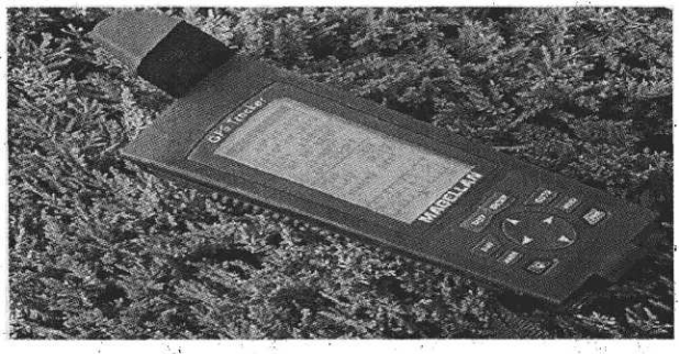
Figure 4: Handheld Global Positioning Systems (GPS). GPS receivers can determine latitude, longitude, and elevation anywhere on or above the Earth's surface from signals transmitted by a number of satellites. These units can also be used to determine direction, distance traveled, and determine routes of travel in field situations.

