The purpose of a geographic information system(GIS) is to provide a spatial framework to support decisions for theintelligent use of earth’s resources and to manage the man-made environment.
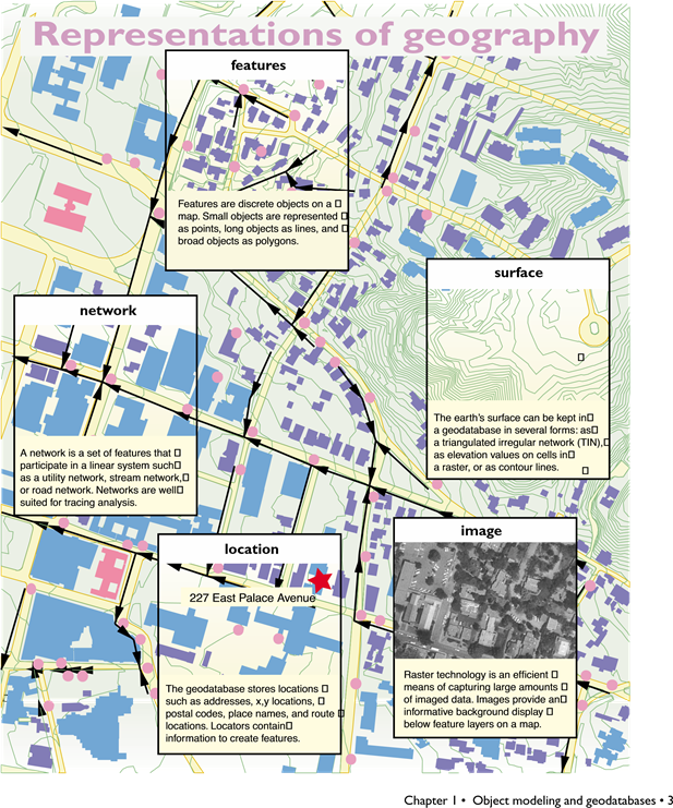
Mostoften, a GIS presents information in the form of maps and symbols. Looking at amap gives you the knowledge of where things are, what they are, how they can bereached by means of roads or other transport, and what things are adjacent andnearby. A GIS can also disseminate information through an interactive sessionwith maps on a personal computer. This interaction reveals information that isnot apparent on a printed map.
For example, you can query all knownattributes of a feature, create a list of all things connected from one pointon a network to another, and perform simulations to gauge qualities such aswater flow, travel time, or dispersion of pollutants.
The way you choose to display andanalyze information depends upon how you model geographic objects from theworld.
MANY WAYS TO MODEL A SYSTEM
Our interaction with objects in the world isdiverse, and you can model them in many ways.
Considerone example, rivers. Rivers are natural features, are used for transportation,delimit political or administrative areas, and are an important feature in theshape of a surface. Here are a few of the many ways you can think aboutmodeling rivers in a GIS:
• As a set of lines that form anetwork. Each section of line has flow direction, volume, and other attributesof a river. You can apply a linear network model to analyze hydrographic flowor ship traffic.
• As a borderbetween two areas. A river candelimit political areas such as provinces orcounties, or can be a barrier for natural regions such as wildlife habitats.
• As an arealfeature with an accuraterepresentation of its banks, braids, and navigable channelson the river.
• As a sinuousline forming a trough in a surfacemodel. From the river’s path through asurface, you can calculate its profile and rate of descent, the watershed itdrains, and its flooding potential for a prescribed rainfall.
MAP USE GUIDES THE DATA MODEL
Itis clear that even a common type of geographic feature such as a river can berepresented in a GIS in a variety of ways. No model is intrinsically superior;the type of map you want to create and the context of the problems to be solvedwill guide which model is best.